Technology
Satellite Technologies Helping the Polish Archaeologists

A team of researchers of the Jagiellonian University in Cracow and the AGH University of Science and Technology in Cracow is looking for a location where one of the greatest ancient battles took place, won by Alexander the Great. The whole project is financed via a grant provided by the National Centre of Science. It takes place in Iraq, in collaboration with the Italian archaeologists of the University of Udine. Satellite technologies play an important role in this project.
Legendary Ancient Battle
The Battle of Gaugamela took place in 331 BC between the Hellenic-Macedonian forces, led by Alexander the Great and the Persians led by the King Darius III. It is said to be one of the most important battles of the ancient times. It was a decisive victory for the Hellenic League and led to the fall of the Persian Empire. It has also paved a way for a new era to start, also commonly referred to as the Hellenistic period. This period shaped the Mediterranean and Middle Eastern cultural heritage. Despite the meaning and relevance of the battle, the location where it took place has not been confirmed. The Polish archaeologists decided to face this challenge and find the battleground.
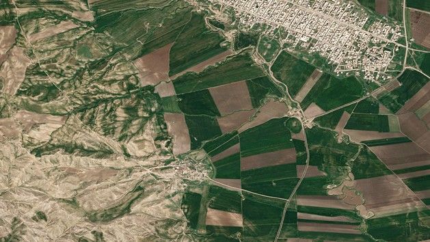
The goal of our project is to determine the precise location of the Battle of Gaugamela, in the light of an interdisciplinary research, with a particular attention paid to the methods used in ancient history research and landscape archaeology. Alongside the ancient and archived sources and contemporary cartographic data, we also use remote-sensing data in our research, in our case – imagery provided by the EO satellites.
Why satellite imagery?
Optical satellite imagery provided by the Airbus Defence and Space Pleiades Hi-Res constellation is being useful in the process of determining the location of the battlefield. The imagery has been delivered by Astri Polska which is an official distributor of the Airbus Group satellite imagery and geoinformation products in Poland. As stressed by the company’s representatives, the high resolution satellite imagery may have a significant advantage over other methods of acquiring geographical information.
The imagery created via the satellites may also be delivered for areas that, due to a variety of circumstances emerging there such as catastrophes, conflicts, are not available for other technologies. Should a need emerge to create similar imagery from an altitude ascribed to aircraft for instance, acquisition of photos may turn out to be problematic. What is more, the Jagiellonian University has selected imagery captured by a satellite a few years ago, for the purpose of its research. Delivery of images as such has been possible thanks to an access to the Airbus Group’s satellite imagery archive, reaching back to 1986.
Growing Interest in Satellite Data in Poland
More and more Polish companies and institutions start to notice the benefits stemming from use of satellite data. This trend has been confirmed by Astri Polska:
– During the recent years we have noticed a significant growth of interest, on the part of the Polish companies and institutions, in using high resolution, commercial satellite imagery. The imagery as such is being used in more and more domains of economy and science, including water and land management, precision agriculture, crisis management, mining or environment protection and monitoring – Michał Wyszyński of Astri Polska added.
Source: Astri Polska
